
Heavy rain will once again lash parts of the Northeast on Saturday, bringing a flood threat to New York City for the second consecutive weekend.
A cold front followed by remnants of former tropical storm Philippe are set to drench areas from northern New Jersey to as far north as Maine. These areas have a slight risk for excessive rainfall from Saturday morning through early Sunday, according to the Weather Prediction Center.
“In addition to the heavy rainfall, gusty winds are expected for eastern Maine along the storm’s track, as well as high surf along the New England coast,” the prediction center said Friday.
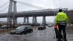
And although forecasters have said this weekend’s storms won’t bring as much rain as last week’s record-setting rainfall that wreaked havoc on New York City’s roads and subway system, some flood watches are in effect Saturday in those same hard-hit areas.
Parts of southeastern New York – including much of New York City – southern Connecticut and northeastern New Jersey are under a flood watch from 2 a.m. Saturday through the evening, according to the National Weather Service.
Much of Maine also will be under a flood watch from Saturday afternoon into Sunday.
Generally 1 to 3 inches of rain are possible Saturday into Sunday from the New York City area and upstate New York to New England. Higher amounts, up to 5 inches, could fall where the heaviest rain sets up, most likely in Maine.
Maine and portions of northern New England are forecast to see the most significant impacts from Philippe’s remnants.
As of Friday morning, the remnants of post-tropical cyclone Philippe were expected to move over parts of the Atlantic Canada and New England this weekend, the National Hurricane Center said.
And this would be the third weekend in a row the Northeast gets walloped by heavy rainfall. Ophelia soaked the Northeast the weekend of September 23, followed by last weekend’s walls of rain that paralyzed air travel, flooded basements and triggered water rescues in New York City.
NYC officials warn of travel disruptions, again
As the storm moves in Saturday, New York City officials are warning residents to be prepared for 1.5 to 2.5 of rain citywide, with the potential for 3 to 4 inches in flood-prone areas.
To that end, a deputy mayor urged basement residents to remove their belongings and move to higher ground by Friday night.
“Since this is happening overnight, you might be asleep so you should be preparing now,” First Deputy Mayor Sheena Wright told reporters Friday.
Wright also implored New Yorkers to plan ahead as grounds still were saturated from last week’s storm, warning that potentially significant flooding and travel disruptions in typical flood prone areas are possible.
“In this time of man-made climate crisis, flash floods and other climate events are a part of our reality,” Wright said. “This is in fact the new normal.”
The city has more than 100 water rescue teams on standby, and crews are working to clear catch basins so they can absorb more water, city officials said in a news conference Friday.
Experts and scientists have said human-induced climate change is a major driver of extreme weather events, which are likely to occur more frequently and severely.
CNN’s Skylar Harris, Jessica Xing and Tayor Ward contributed to this report.